Deadly Flash Flooding Strikes New Jersey and New York: At Least Two Dead, Transit Systems Overwhelmed
Severe flash flooding swept through parts of New Jersey and New York overnight, leaving at least two people dead, inundating subway stations, and crippling transit infrastructure across the region. The powerful storm system unleashed torrential rain across the Tri-State Area, prompting states of emergency and widespread disruption.
Fatalities and Emergency Response
Authorities in Plainfield, New Jersey, confirmed the deaths of two individuals after their vehicle was swept into a swollen brook late Monday night. Emergency crews recovered the bodies early Tuesday morning as rescue operations continued throughout the region.
New Jersey Governor Phil Murphy declared a state of emergency and urged residents to avoid non-essential travel. “The flooding is dangerous and unpredictable,” he said during a press briefing. “We are working closely with local authorities and transit agencies to respond swiftly.”
Infrastructure Under Water
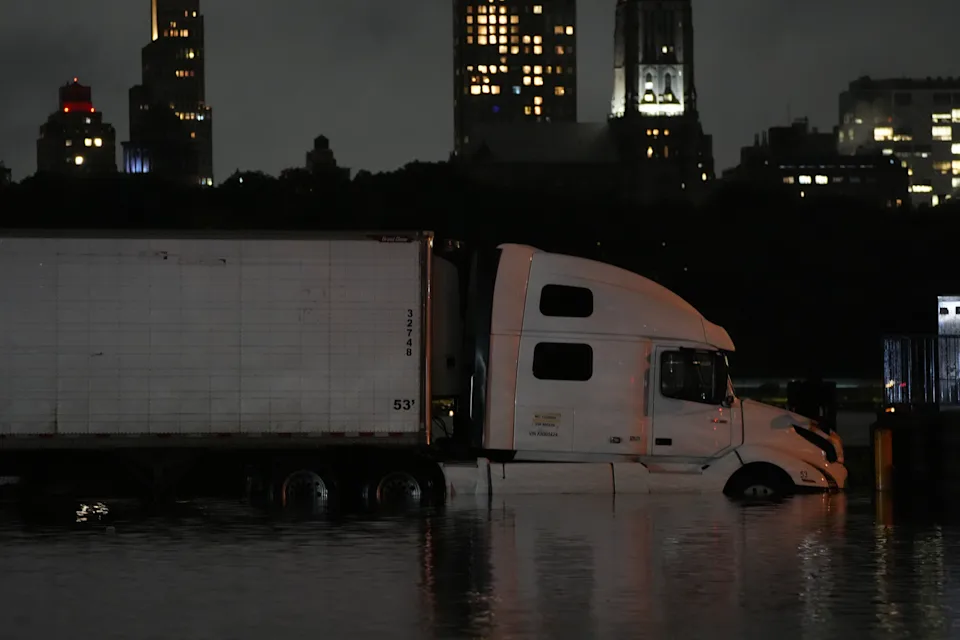
In New York City, the storm dumped more than six inches of rain in a matter of hours—marking the second-wettest one-hour period in the city’s recorded history. The rapid deluge overwhelmed storm drains and subway infrastructure, with multiple subway lines—including the 1, 2, 3, E, F, M, and R—forced to suspend service overnight.
Photos and videos circulating on social media showed commuters wading through waist-high water in some stations, while others were stranded on flooded platforms. The MTA worked through the night to clear tracks and restore operations in time for the Tuesday morning commute, but delays and rerouted services persisted throughout the day.
A Broader Regional Crisis
The flash flooding extended beyond New Jersey and New York, affecting portions of Pennsylvania, Connecticut, and Westchester County. Flash flood warnings were issued across a broad swath of the Northeast, with officials warning of the continued threat of river swelling and saturated soil.
Transportation officials closed sections of the New Jersey Turnpike and Garden State Parkway due to impassable conditions. In Newark, more than a dozen water rescues were conducted after vehicles became trapped beneath underpasses.
More Rain on the Way
Forecasters warn that the threat is far from over. Another round of heavy rain is expected to impact the region through mid-week, raising concerns about additional flooding. The National Weather Service has issued continued flash flood watches for affected areas, citing saturated ground and full reservoirs as aggravating factors.
“This is a dangerous pattern,” said meteorologist Leah Ramirez. “With the soil already saturated and waterways elevated, any additional rainfall could have serious consequences.”
Calls for Resilience and Climate Preparedness
The disaster has renewed calls for improved infrastructure resilience in the face of increasingly frequent extreme weather events. Climate scientists note that warming global temperatures are leading to more intense rainfall episodes, a trend already evident in cities like New York.
Mayor Eric Adams emphasized the need for long-term planning: “We can’t continue responding to these events as isolated incidents. This is the new normal, and our infrastructure must evolve to meet it.”
⚠️ What Residents Should Do:
Avoid driving through flooded areas—even six inches of water can be deadly.
Stay tuned to local weather alerts and emergency announcements.
Ensure sump pumps, drains, and emergency supplies are ready at home.
Report flooded streets and infrastructure failures to city services.
As of Tuesday afternoon, cleanup efforts are underway across New Jersey and New York. The full extent of the damage remains unclear, but officials warn that the region may need days—if not longer—to fully recover.
Share this content:


Post Comment